On 9/4/2005,
Julie and I flew back to Cedar Key in a 172SP from Peter O’
Knight in Tampa to meet her cousin and his family who were staying
on Cedar Key for the Labor Day weekend. I didn’t shoot a lot
of pictures this time, partly because it was so hazy and partly
because we’ve been there before. The main difference this
time was that we got to see the town and met people we already knew
up there, so it was nice. It was also nice because we were able
to get them to take a quick look at the runway condition before
we took off and tell us if it was clear or not. With nobody taking
care of the runway, the recent storms could have rendered it dangerous
to land on.
We did our preflight
at about 7:30 am or so, and were ready to go by 8:00 or 8:15. Our
original plan was to take off from Peter O’, then go around
the edge of Tampa Bay over Apollo Beach, around to Anna Maria Island
and across the Skyway bridge, then go up the coast from Ft. Desoto
all the way up to Cedar Key. However, once we were aloft, I could
see that it was even more hazy over the Bay and along St. Pete,
so we took an alternate route instead.
Since I hadn’t
flown the plane we had that morning in over a year and I didn’t
want my first short-field landing in this plane after all this time
to be on Cedar Key, I decided to stay in the pattern for at least
one practice landing. Julie was OK with this, so I made my announcements
and lifted off. My practice landing was right on the numbers and
I actually had to taxi to the first turn-off, so I was happy with
this and we took off for Cedar Key right afterward.
As soon as we
were up to pattern altitude, I departed the pattern to the North
East and we were on our way.
As I said before,
it was very hazy. The weather data said that we’d have 10
mi of visibility, with scattered at 3,000 ft and ceilings at 25,000
ft., with the haze burning off around 10:00 am. We had the 10 miles
of visibility, but there was a very scary layer of haze that just
wouldn’t budge. I tried to climb above it, but realized it
went up to about 4,000 ft. and didn’t want to get stuck above
it if it got thicker. It seemed to thin somewhat near the bottom,
which was about 1,200 ft. above sea level, so I opted to fly at
about 1,500 ft where I could easily see below it and had a reasonably
good view up through it too.
We had a headwind
of about 15 Kts. All the way there, but it was fairly consistent
and the ride wasn’t too rough at all. We flew right up I-75
to Pasco County and turned North/Northwest at Tampa North (X39)
and headed for Hernando County (BKV) and then on to Crystal River
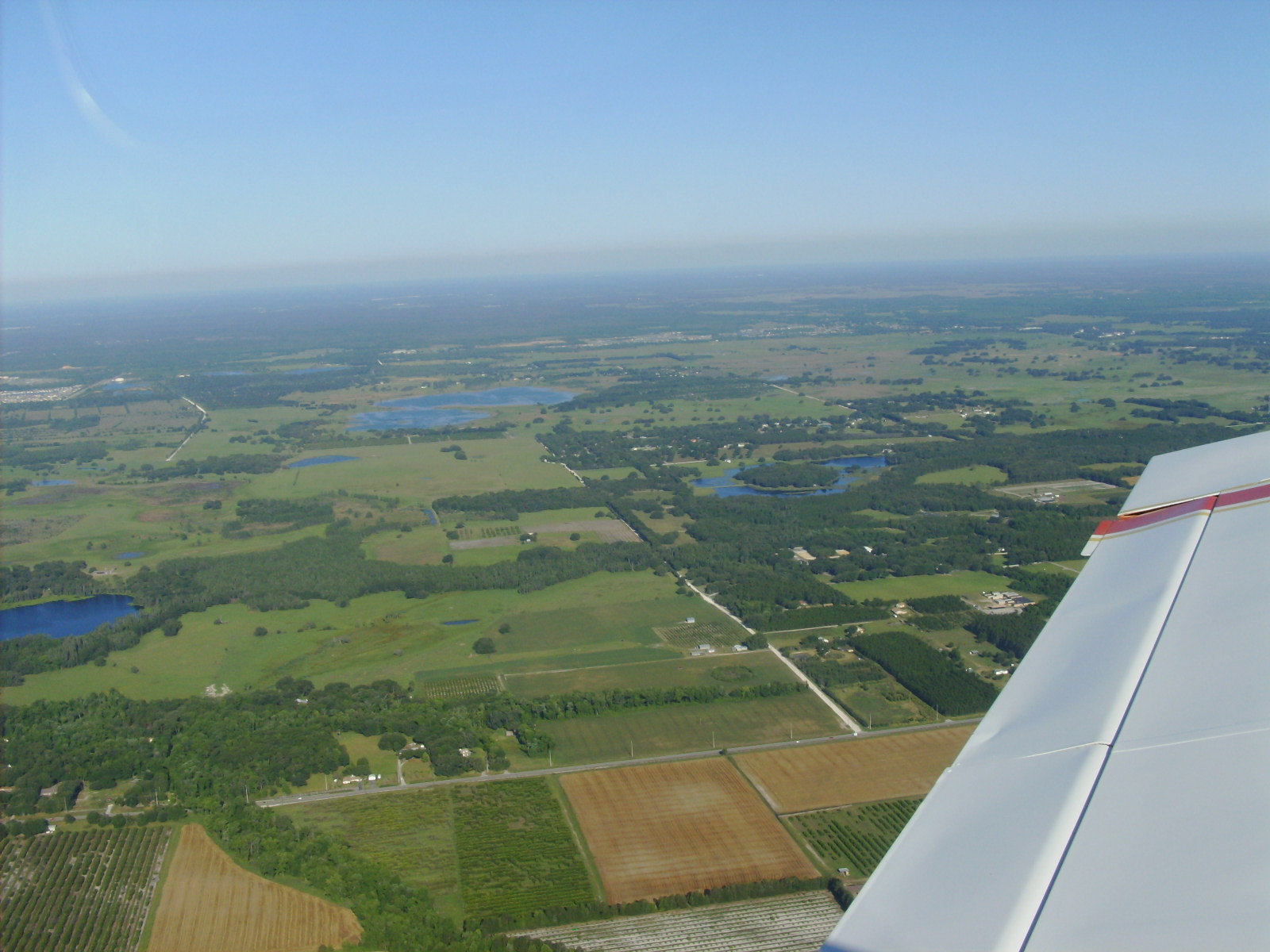
(CGC). After Crystal River, we continued on up to the “Big
Bend” of Florida and crossed Waccassassa Bay. We then followed
the coast on around to Cedar Key (CDK). This is a beautiful area
of the state and features some really desolate stretches of coastline
and inland forests. This is the truly unspoiled Florida that most
never see. There are wading birds and all kinds of critters below
us, along with pristine cypress trees and water so black and smooth
it looks like a dark mirror. I really love flying low and slow over
this terrain and just sight-seeing. Julie likes to fly low too,
so she was good with this course.
The only real
down-side was the damned haze and the need to be extra diligent
for other aircraft and obstacles, etc. On the up-side, there were
a lot fewer planes out and about that Sunday, probably due to the
same haze factor we were dealing with.
Anyway, we found
the tiny island runway without any problems, and swung in over the
town to descend to TPA. As we turned to the base leg of our approach,
the local taxi service called on the radio to see if we needed a
ride into town. The local taxi service has been run by the same
family for generations. Sometimes they come out and get you with
their ancient old Checker cab, and sometimes it’s their personal
grocery-getter – whatever they’re driving at the time!
There’s no set fee for this, but I understand that it’s
customary to pay them about $7.00 for the trip. The trip is all
of two miles, if they go the long way.
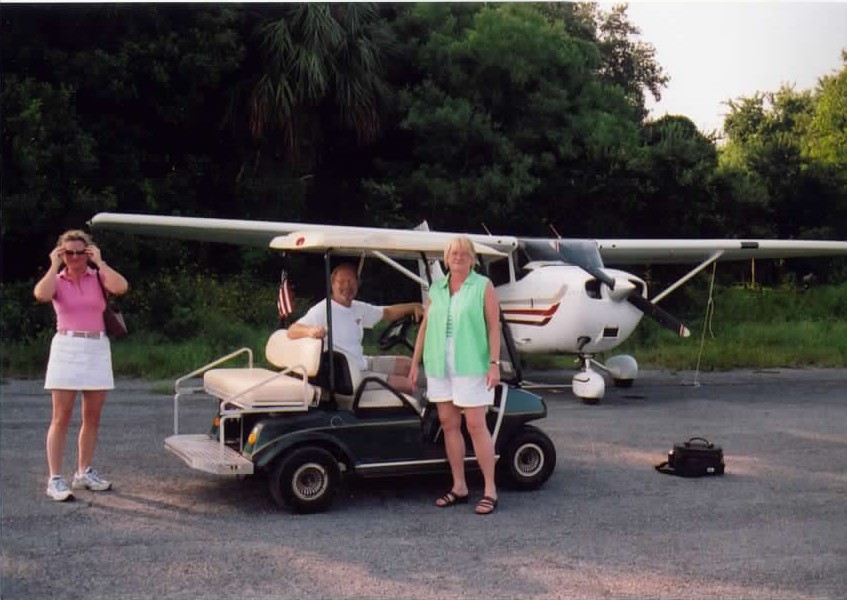 In
our case, Julie’s cousin Doug and his wife Heather were waiting
for us in a little golf cart with seating for 4 at the end of the
runway. I made a beautiful short-field landing (Cedar Key is only
about 2,000 ft) and then back-taxied on the runway to tie down.
If you’re going to Cedar Key, take your own tie-down rope.
The airport has no facilities of any kind (not even water) and although
there are cables along the tie-down area, the ropes have long since
rotted or been cut away, etc. I knew this from a previous trip and
took some ropes along in my flight bag. I tied us down amongst the
three or four other planes that were there and we went on in to
town. In
our case, Julie’s cousin Doug and his wife Heather were waiting
for us in a little golf cart with seating for 4 at the end of the
runway. I made a beautiful short-field landing (Cedar Key is only
about 2,000 ft) and then back-taxied on the runway to tie down.
If you’re going to Cedar Key, take your own tie-down rope.
The airport has no facilities of any kind (not even water) and although
there are cables along the tie-down area, the ropes have long since
rotted or been cut away, etc. I knew this from a previous trip and
took some ropes along in my flight bag. I tied us down amongst the
three or four other planes that were there and we went on in to
town.
Doug and Heather
are extremely good hosts, and had a little golf cart tour of the
town planned out for us. We checked out the local hot spots and
places of interest and even stopped at the ancient old hotel on
the marina. I think it’d be cool to stay there for a night
or two some day. After we took in the local sites, we went back
to the condo they had rented for the weekend and met up with their
two kids Jake and Lizzy, and a friend that Lizzy had brought along
on the trip.
Heather made
us all Eggs Benedict!!! Now, I’ve always said that I’ll
fly pretty much anywhere for a free meal, but this was way more
than I had actually expected. It was delicious, and made me wanna
sit around for a while with my pants unbuttoned, but decorum prevailed
and I just imagined it instead. What a spectacular view they had!
Three floors up and right on the ocean – sweet.
After breakfast,
the kids took us back to the airfield in the golf cart, and the
folks followed in the car. I did shoot this one shot of the whole
gang in front of the plane before we left.
While we were
taking the picture, another 172 came in for a landing and things
almost got ugly. He flared about 6 feet above the runway, and just
hung there. By this time we had a fairly consistant headwind of
about 12-14 Kts. Blowing down runway 05 @ 060 degrees. He had 40
degrees of flaps out, and looked like it was gonna pancake in at
any second. There’s not a lot of runway there to dilly-dally
around and make the tuff decisions, either. You pretty much want
to get down quickly or go around. This guy just hung there though,
like he was on a wire. Finally, after what seemed like an impossibly
long time, he tickled the gas a little and coaxed her down at about
the halfway point. When they taxied in to the tie-down area, his
passenger looked a little shook up to me. We could hear the old
pilot (early seventies, I’d guess) telling the passenger he
had to come anyway, but that he was glad for the company. We figured
he must have a place there or something like that.
 Back
in the plane, we got ready to depart. My hand-held GPS unit was
acting up, and I never bothered to learn how to use the one in this
plane, so we decided to use pilotage and dead reconning to find
our way home. I had plotted out the flight plan for both directions
the night before, like I always do. I do this partly because it’s
the safest way to do things, and partly because I get so excited
before a trip that it helps me deal with the wait. Anyway, we followed
our course and matched up the way points and all went very well.
Julie is getting much better at helping spot the way points, and
can actually look at the chart and find the features on the ground
that are depicted on the chart. Spotting the Big Bend and the nuclear
power plant at Crystal River were easy, then we just followed our
headings down to Hernando County and then across to Tampa North.
Then we just followed I-75 back down into Tampa and made our approach
from the Brandon side of town toward Peter O’. Back
in the plane, we got ready to depart. My hand-held GPS unit was
acting up, and I never bothered to learn how to use the one in this
plane, so we decided to use pilotage and dead reconning to find
our way home. I had plotted out the flight plan for both directions
the night before, like I always do. I do this partly because it’s
the safest way to do things, and partly because I get so excited
before a trip that it helps me deal with the wait. Anyway, we followed
our course and matched up the way points and all went very well.
Julie is getting much better at helping spot the way points, and
can actually look at the chart and find the features on the ground
that are depicted on the chart. Spotting the Big Bend and the nuclear
power plant at Crystal River were easy, then we just followed our
headings down to Hernando County and then across to Tampa North.
Then we just followed I-75 back down into Tampa and made our approach
from the Brandon side of town toward Peter O’.
We arrived back
at Peter O’ 15 minutes before the plane was due back, and
loaded our junk into the X-terra and headed back to Zephyrhills.
What a great
flight we had! We had a little wind (strong tailwinds aloft on the
way back!), we had a short runway with water at each end to deal
with, we had haze to peer through, and we had no GPS to use as a
cross-country crutch. And yet, this was an extremely enjoyable adventure
for us both. We met people at a remote location at a pre-determined
time, and made the entire round trip in less time than they took
just to get there! I think Julie’s just starting to get the
airplane bug, and this’ll go a long way toward future trips
together. I’ve since been checked out to rent from Zephyrhills
airport (ZPH), so we’ll be able to just pop over there (1.2
miles away from home) when we’ve got an hour or two and just
go flying.
If you are interested in a particular airport, or want to be able
to pull up a list of airports that match a certain set of criteria,
check out the Online Airport Facilities Guide on this site. You can search by city, services, facilities, restaurants
and more!
Until next time,
fair winds and blue skies,
Wingnut. |